 iStock
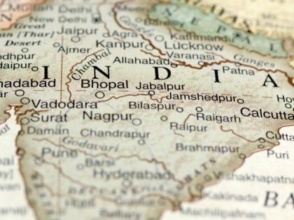
Every now and again, New Delhi gets its dander up because someone or the other, somewhere or the other, publishes a map of India that does not show Kashmir as being part of the country. Questions are raised in Parliament as to how this insult to the country's national integrity was permitted, and patriotic-minded citizens immolate copies of the offending depiction in public.
But India is not the only country to wax wroth over contumacious cartography. An indignant resident of Rio de Janeiro has moved a court seeking a municipal ban on the atlases being issued for geography classes in local schools. The reason for the carioca's umbrage is that the books in question feature maps based on the standard Mercator model which, inaccurately, shows the US state of Alaska to be the same size as Brazil, while in fact the South American country is almost five times larger than the northern territory that the bought from Russia in 1867 for $7.2 million.
While the Brazilian is justifiably exercised at his country being cut down to less than size, maps based on the Mercator projection also contain several other anomalies of magnitude. The ice-bound - and inappropriately named - country of Greenland is depicted as being bigger than the African continent, when in actuality the latter is 14 times larger than the northern nation. Africa is shown to be similar in size to Europe, even as it is almost three times more expansive. Antarctica, in the world according to Mercator, is the biggest continent whereas in terra cognita, it is the fifth largest.
The reason for these inaccuracies is that the Mercator projection, designed by the Flemish cartographer Gerardus Mercator in 1569, represents the three-dimensional sphere of Earth on the two-dimensional surface of paper. The result is that areas closer to the North Pole and the South Pole appear disproportionately larger than those closer to the Equator. Despite such misrepresentations, the Mercator projection became an indispensable asset in oceanic navigation as it enabled ships to chart a straight-line course for their routes.
Gerardus was much more than just a maker of maps. An accomplished mathematician, he applied the science of numbers to geography and astronomy, a union which he found 'extremely agreeable'. His aim, as he wrote in his 1578 treatise, Introduction to Ptolemy's Geography, was to arrive at 'not only the description of the Earth, but also the structure of the whole machinery of the world, whose numerous elements are not known by anyone to date'.
He taught himself the art of engraving, on metal and wood, and in 1536 he designed a terrestrial globe for Charles V, the first of many which he crafted, some of which are extant today. Mercator was an enthusiastic debater on philosophic themes, and had he been around now he would have welcomed the discourse, often contentious, surrounding his most renowned creation. For while maps based on his projection continue to be used to aid navigation and to teach the elements of geography to students, there is a growing body of controversy regarding the political, social, and cultural implications of the cartographic distortions inherent in his projection.
Critics take to task the implicit, though unintended, racism through the prism of which Europe and North America are shown to be much larger than they are in comparison with Africa, Asia and South America, thereby endorsing the concept of White superiority and indirectly justifying the history of subjugation and colonialism. In response to such objections, present-day cartographers have devised substitute projections - like the Gall-Peters representation, gaining usage both in corporate and scholastic spheres, which attempts to show countries and continents in correct size but which tends to get them elongated at the equator and compressed in the higher latitudes near the poles.
A truly true map of the world is a logical impossibility. It would not only have to be as large as the world itself, but it would also have to include in itself a map as large as itself, and so on ad infinitum. 'Geography is about maps/ While history is about chaps,' goes the old doggerel. But it seems that history can also be about maps and the chaps who make them.
( Originally published on Jun 04, 2022 )
(Disclaimer: The opinions expressed in this column are that of the writer. The facts and opinions expressed here do not reflect the views of www.economictimes.com.)


 Get Unlimited Access to The Economic Times